
|
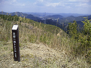
| ■Keihoku Course (Hosono (starting place) ―Hosono (finishing place), 35.4km, Trail Board Number from K1 to K19, 5.5km) |
| From Shimokumata to Hosono (Trail Board Number from 68 to 1)/ Shiroyama (Trail Board Number from 71 to the ruin of Shuzan-jyo Castle, and to Shuzan) |
 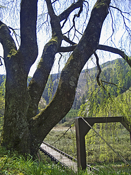 |
| Left: Top of Mt. Kuroo-yama Right: Suspension bridge over Uogafuchi and Shidare cherry tree (cherry tree with drooping branches) |
|
From the junction of three streets (Trail Board No. 68), go into the mountain side. As there are many branch points and turning points, check the map carefully. Turn to the left at Trail Board No. 69 to Kuroo-rindo forest road. This road heads to the north-west branch ridge through the just below the top of Mt. Kuroo-yama (509.4 m). Go straight to the grave yard (Trail Board No. 70) and turn to the left steeply. Go zigzag path to the branch ridge, and you will hit Kuroo-yama-rindo (forest road) which comes down from the above. It is a logging area around here and you can enjoy the open view to the west. Go up the ridge from the forest road to Trail Board No. 71-1 and go down to the right. Walk down carefully on the steep slope. If you keep going up the ridge further from the board, you will reach the top of Mt. Kuroo-yama. Go around into the west slope, traverse the mountainside, and go down by degrees to Shimotani-rindo (forest road). Go down the path along the valley in the forested area to Kashiwabara. Go to the east on Route 477 and take the right path along Kamikatsura-gawa River at Trail Board No. 76. There are a stone marker put up in 1917 and a board of Kinki-shizen-hodo (nature trail). Pass through the village of Uogafuchi, where there are beautiful Dozo (storehouses) and Tanba style houses. Cross the suspension bridge at the east end of the village. You can enjoy beautiful sight of Shidare cherry tree (cherry tree with drooping branches) close to the bridge. |
 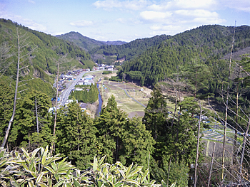 |
| Left: You can enjoy mountains' view in Tanba-highland from Trail Board No. 87 Right: View of Hosono Village from Mt. Goten-yama* |
|
Cross to the left bank (there is a house) to the branch ridge. Trees on the west slope were logged and the view toward the lower reaches is good. As the trail path and roads for forestry work are running intricately in some parts, take the path carefully. (Takase-no-michi Path) After hitting Ookawa-omote-rindo (forest road), take the path toward Kurio-toge Pass. The view to the north becomes fine and you can enjoy the views of Shuzan basin and mountains in Tanba-highland. Trail Board No.87-1 is important. Turn to the right to the mountain path. If you miss the branching point, you will go on the forest road to Kurio-toge Pass. Around the ridge toward the south, there are secondary forest and forested sites one after the other. This area used to be a territory of the Nijyo Family and the path is called "Nijyo-san's sanpo-michi (walking trail)". Go down to the east valley to Hosono from the path toward Mt. Goten-yama. Go toward the upper reaches along Hosono-gawa River. After seeing Kasuga-jinjya Shrine, you will reach the starting place. *: Mountains other than those in the Course |
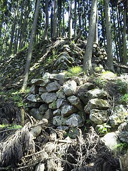 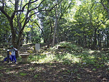 |
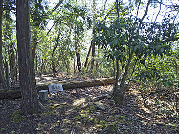
| Left: Piled stones of the old castle on the ridge Right: Honmaru (castle's keep) of Shuzan-jyo Castle |
|
New trail course goes to the north-east along the ridge over the top of Mt. Kuroo-yama from Trail Board No. 71. At the point where you see a small peak on the tip of the ridge, take the right mountain path or the track by a person or an animal. It leads to the south-east through the remains of Kuruwa (walls of a castle). Go down the left ridge way to Shiroyama through the steel tower for the power lines. There is a ruin of Shuzan-jyo Castle at the flat place on the top. There still remain big walls and well on the west and north side. It is said that Mitsuhide Akechi built this castle but he did not live there. Go down the ridge way to the east. Take the north branch ridge way to the valley. Finally you will be led to the center area of Shuzan. As this course is not yet well maintained, you should not use this course if you are not good at root-finding. The condition of the path from Shuzan to the ruin of the castle is in good shape. 《Approximate time required》 Board Number 68 (junction of three streets) (60min.) Board Number 71-1(branching point to Mt. Kuroo-yama) (50min.) Kashiwabara (Board Number 75) (35min.) Uogafuchi (Board Number 79) (60min.) Board Number 87 (60min.) Hosono (Board Number 1) Board Number 71(branching point to Mt. Kuroo-yama) (50min) Shiroyama (40min.) Shuzan |
| → Keihoku Course (Trail Board Number from K1 to K19 and from No.34 to No. 68) |
| → Keihoku Course (Trail Board Number from 1 to No.34) |
| → High points |
| → Back to the Top of this Page |
| © Kyoto Trail Guide Association |