| ■For Walking on the Trail |
 |
| Kyoto Alpine League and the KYOTO TRAIL Association have published the following Trail Course Maps (official maps of the Kyoto Trail) and reference documents for walking on the trail safely. Your Trail Walking will become a fully enjoyable one if you have a total image of the trail before you start. |
|
| "The Kyoto Trail Official Guide Map" [published by the KYOTO TRAIL Association] |
|
 | | ●Kyoto Trail Digest
(Higashiyama-3 course, Nishiyama-1 course) JPY 300
Eujoy a pleasant leisurely stroll through the peacefyl streets of Kyoto.
Mt.Daimonjiyama Hiking Course (From Subway Keage Station to Keihan Line
Demachiyanagi Station)
Outlook Course (From Keiha Line Kiyomizu-Gojo Station to Subway Higashiyama
Station)
Beginners' Course (From Keihan Line Fushimi Inari Station to JR/Keihan line
Tofukuji Station)
Colored Leaves and History Course (From JR Bus Makino-o Stop to Arashiyama) |
|
 | | ●Higashiyama Course
(From Fushimi Inari Station to Hiei Station of Cable Car) JPY 600
Many popular sightseeing spots are located along this course, and you can enjoy
Kyoto'sculture and nature. This course is recommended also for new beginners. |
|
 | | ●Eastern Kitayama Course(From Hiei Station of Cable Car to Ninose)
JPY 600
After walking across great Mt. Hiei located in north east of Kyoto, you go to
Shizuhara and Kurama through Ohara. You can enjoy beautiful sceneries
in the mountain and rural areas along this course. |
|
 | | ●Western Kitayama Course (From Ninose to Kiyotaki) JPY 600
Around Takao and Kiyotaki areas, you can enjoy Kitayama cedar groves and
colorful autumn leaves. Also, you can catch a glimpse of history and culture of
the old capitalaround Himuro and Kyomi path areas. |
|
 | | ●Nishiyama Course (From Kiyotaki to Koke-dera Temple) JPY 600
After enjoying dynamic sights of mountain streams of Kiyotaki River and Hozu
River, you will be led to Sagano and Arashiyama area where there are many
sightseeingspots. You will have a day full of variety. |
|
 | | ●Keihoku Course (From Hosono to Kuroda) JPY 600
In all seasons, this course offers you rich variety of sights such as Takimatano
taki Falls, Jyoshokoji- Temple, One hundred-year-old Cherry tree, ruin of Shuzan
Castle and Uogafuchi. |
|
|
| 『京都一周トレイル/Kyoto Trail Guidebook』[京都トレイルガイド協会=編著] |
|
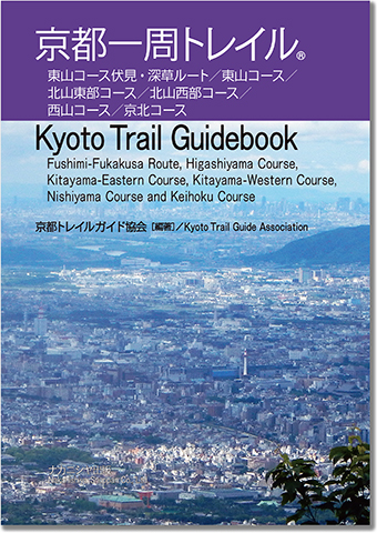 | ●We hope you enjoy Kyoto with this book.
Nakanishiya Shuppan Co., Ltd. First Edition Jan. 2020
(Kyoto Trail Guide Association)
ISBN978-4-7795-1430-2 C0025 JPY 1,980
Outline
アクセス(主要駅・バス停)/ Access
東山コース 伏見・深草ルート/ Kyoto Trail, Fushimi-Fukakusa Route
深草トレイル/ Fukakusa Trail
東山コース/ Kyoto Trail, Higashiyama Course
北山東部コース/ Kyoto Trail, Kitayama-Eastern Course
北山西部コース/ Kyoto Trail, Kitayama-Western Course
西山コース/ Kyoto Trail, Nishiyama Course
京北コース/ Kyoto Trail, Keihoku Course
コースマップ/ Maps
東山コース 伏見・深草ルート/ Kyoto Trail, Fushimi-Fukakusa Route
東山コース/ Kyoto Trail, Higashiyama Course
北山東部コース/ Kyoto Trail, Kitayama-Eastern Course
北山西部コース/ Kyoto Trail, Kitayama-Western Course
西山コース/ Kyoto Trail, Nishiyama Course
京北コース/ Kyoto Trail, Keihoku Course
コースインフォメーション/ Information
地名索引/ Index《Place name》
Nakanishiya Shuppan Co., Ltd. |
|
|
|
| 『京都一周トレイル マップ&ガイド』[京都トレイルガイド協会=編著] |
|
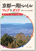 | ●We hope you enjoy Kyoto Trail with this book.
Nakanishiya Shuppan Co., Ltd. First Edition Nov. 2021, 2022
(Kyoto Trail Guide Association)
ISBN978-4-7795-1587-3 C0025 JPY 1,540
〔内容〕
アクセス
東山コース1 伏見・深草ルート
東山コース2 京阪「伏見稲荷」駅〜蹴上
東山コース3 蹴上〜浄土寺橋
東山コース4 浄土寺橋〜叡山ケーブル「ケーブル比叡」駅
北山東部コース1 叡山ケーブル「ケーブル比叡」駅〜京都バス「戸寺」
北山東部コース2 京都バス「戸寺」〜京都バス「二の瀬」
北山西部コース1 京都バス「二の瀬」〜京見峠登り口
北山西部コース2 京見峠登り口〜高雄白雲橋
西山コース1(一部北山西部コースを含む) 高雄白雲橋〜嵐山渡月橋
西山コース2 嵐山渡月橋〜苔寺谷
京北コース1 細野〜亀甲橋
京北コース2 亀甲橋〜おーらい黒田屋
京北コース3 山稜橋〜保井谷橋
京北コース4 保井谷橋〜細野・保井谷橋〜ウッデイー京北
京都一周トレイル 立ち寄りスポット
Nakanishiya Shuppan Co., Ltd. |
|
|
| 『「京都一周トレイル」で、東山・北山・西山を歩く 京の絶景と名所旧跡めぐり』[京都府山岳連盟=監修] |
|
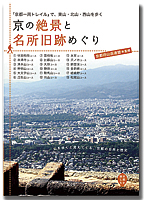 | ●「京都を愉しむ」をテーマにしたシリーズ
(執筆・写真=竹内康之・湯浅誠二・山本時夫)
トレイルに点在するビューポイントからの眺望。これまで知らなかった絶景。
京都一周トレイルを歩くための基礎的な事柄と案内をベースに、コース近くの立ち寄りたい名店も紹介しています。頼れる1/26000のコースマップを掲載。
〔内容〕
京都の自然と「京都一周トレイル」
山歩きのいろは〔服装・持ち物/歩き方・マナー/地図の読み方・山の天気/アクシデント対応〕
【東山=7コース】
伏見稲荷コース・泉涌寺コース・清水山コース・神明山コース・大文字山コース・
瓜生山コース・雲母坂コース
【北山東部=4コース】
比叡山コース・大原コース・静原コース・鞍馬山コース
【北山西部=4コース】
向山コース・氷室コース・沢ノ池コース・錦雲渓コース
【西山=3コース】
金鈴峡コース・嵯峨野コース・松尾山コース
・A5判 128頁 並製 カラー+モノクロ カバー装
淡交社 定価=1760円 2014年4月発行 |
|
|
| These official guide maps are available for purchase at the following shops.Go hiking with the maps! |
Kita Ward=Ogaki Shoten (Main Shop, VIVRE Shop, Bukkyo Univ. Shop)
Kamigyo Ward=Plein Air
Sakyo Ward=Kyoto City Tourist Association, Kyoto City Tourist Association Tourist Information Center,
Kansai Map Center, Ogaki Shoten (Iwkura Shop)
Nakagyo Ward=Kyoto City Hall Tourism Planning Section, Kandahar Kyoto Shop, Lodge Kyoto Shop,
Bunshodo,Mont-bell Club Kyoto Shop, B.B.A., Junkudo Kyoto BAL Shop, c.coquet-
communication service,Ogaki Shoten (Karasuma Sanjo Shop, Nijo Statin Shop, Shijo Shop)
Shimogyo Ward=Kyoto City Tourist Information Center (Kyoto Station 2nd Floor),
Seven-Eleven Hankyu Omiya Station South Shop
Junkudo Kyoto Shop, Paruna Shobo, Ogaki Shoten (Takashimaya Kyoto Shop,
Yodobashi Kyoto, Shop), Kojitsu Sanso Yodobashi Shop
Minami Ward=Ogaki Shoten (Ion Mall Kyoto Shop)
Ukyo Ward=Kyoto City Utano Youth Hostel,
Ogaki Shoten (Kyoto Family Shop, Ion Mall Kyoto Hana Shop), Cap Shoten Saiin Shop,
Momijiya, Takao Kanko Hotel, Kinsuitei, Kinsuitei Branch Shop, Yamamoto Shokudo,
Suzuriishitei, Aoki Car Park, Ichimonjiya, Chiraku, Nakaya,
Kyoto City Saga-Toriimoto Machinami Hozon-kan, Woody Keihoku, Pension Atagomichi,
Kyoto Seminar House, Orai Kurodaya
Nishikyo Ward=Book Pal Bunen(Gojo Shop, Katsuraminami Shop)
Fushimi Ward=Nishimuratei, Hushimi Shobou, Ogaki Shoten Daigo Shop, Fushimi Shop)
Uji City=Ogaki Shoten Rokujizo Shop
Kameoka City=Ogaki Shoten Kameoka Shop
Muko City=Ogaki Shoten Namuko Shop
Osaka City=Buyodo Osaka Shop
Hirakata City=Kojitsu Sanso VIE-ORNER Hirakata Shop
Takatsuki City=Kojitsu Sanso Takatsuki Shop, Ogaki Shoten Takatsuki Shop
Otsu City=Kojitsu Sanso Foreo Otsu Satoyama Shop, Ogaki Shoten Foreo Otsu Satoyama Shop
Tokyo=Kyotokan (JR Tokyo Station Yaesu Chuo Exit), Buyodo Tokyo Shop |
|
| Trail Boards on the Trail |
 | | On the Trail, there are sign boards with numbers and arrow signs to give you correct direction. Numbers on the boards are corresponding to the numbers on the official guide maps. Checking the sign boards on the trail is very helpful for finding next destination. Also at the complicated terrains there are subsidiary sign boards with main number and branch number such as 1-1 and 1-2.
←Trail Board (Trail Board Number 1 of Higashiyama Course) (upper)
Trail Board and Information Board (lower) |
| Notes for Walking on the Trail | |
In some places, the trail paths run through private properties, grounds of temples and shrines, residential areas, etc. Please understand that walking on the Trail is not possible without cooperation of the local people. Never do problematic act in agricultural and forestry area such as breaking off branches and ruining farm crops. Do not disturb religious training and ritual around temples and shrines. Also do not annoy local residents.
●Do not litter cigarette butts and do not make fire in the mountains to avoid forest fires.
There are no facilities necessary for fire extinguishing activities in the mountains. Forest fires will not
only cause harm with damage of burning of trees and shrubs but also cause an unexpected big disaster.
●Do not talk loudly near residential area.
Local residents near the trail may feel uncomfortable with loud voice; therefore, please walk through
local residential areas with a soft voice.
●Bring all your garbage back home to keep the Trail clean.
There are no garbage boxes along the Trail. Bring back your all garbage such as empty cans and empty
lunch boxes.
●Do not pollute rivers.
Some local residents near the Trail use river water for drinking and daily life.
●Do not damage mountain's good.
Do not take any wild vegetables and wild flowers.
Do not put tapes and strings on trees because it may restrain the growth of trees.
●Do not enter the "no-go areas".
Do not stray from the Trail course because there are some very dangerous
places outside the Trail. Even on the trail there are some dangerous places.
Please walk through dangerous places with particular attention. Also do not enter private properties and
temples without permission as it may cause trouble.
●Do not get into the Trail paths by motorcycles and bicycles.
Please enjoy the Trail on foot and do not ruin the trail paths.
●Go to the toilet before you start the walking.
Please refrain from using bathroom of local residence near the Trail.
Please use public toilets which are on a "List of available toilet facilities near the Trail".
●Consider in advance what to do in case of sudden change of weather,
fatigue and unexpected accident. | | |
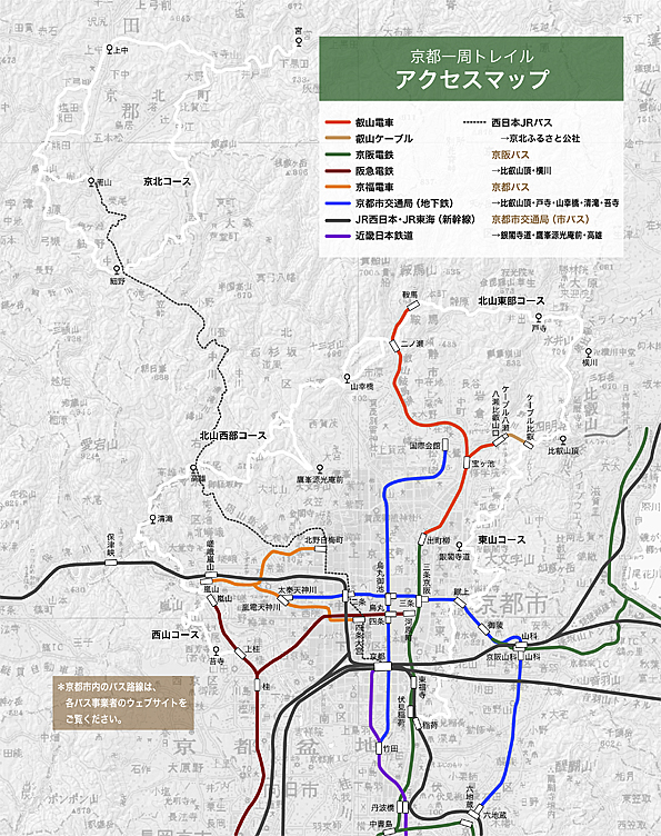
| Access Information | |
| The Kyoto Trail | |
In 1989, Kyoto City developed "Plan of Healthy Kyoto City" in order to promote Kyoto citizens' health.
The project of the Kyoto Trail was set up in order for Kyoto citizens to be healthier and to have more opportunities to experience beautiful natural landscape and historic heritages and cultural assets located at the foot of mountains that encircle Kyoto Basin.
In 1991, evening paper of The Kyoto Shimbun widely reported that Kyoto City and Kyoto Alpine League started a study project for trail path on which Kyoto citizens in any generation could enjoy hiking with families, and the citizens raised their interest and expectation toward the trail.
In May 1993, the Trail was opened starting with Higashiyama Course. And now, not only Japanese but also people from abroad are visiting the Trail.
The Trail has been maintained by the KYOTO TRAIL Association structured by Kyoto City, Kyoto City Tourism Association, Keihan Electric Railway Co.,Ltd., Hankyu Railway, West JR Bus Company, Kyoto City Transportation Bureau, KINKI・CHUGOKU Regional Forest Office Kyoto Osaka Office, Keihoku Community Association and the Kyoto Alpine League. | |
| List of available toilet facilities near the Trail | |
|
Higashiyama Course | Trail Board Number 1 of Higashiyama Course
(one hundred meter ahead of the Board No.1, in the park)
Fushimi Inari Taisha Shrine (next to the main hall, several places in the shrine ground)
Trail Board Number 8 of Higashiyama Course
(turn to the left at the branching point of the Board No. 8, resting place in Imakumano-Kannon)
Trail Board Number 21 of Higashiyama Course (in the parking area of Shogun-zuka
(public toilet))
Trail Board Number 51 of Higashiyama Course
(one hundred meter ahead of the Board No. 51, next to the Ginkaku-ji Koban (public toilet))
Trail Board Number 53 of Higashiyama Course
(ahead of the Board No. 53, guide person's Kitashirakawa Shibuse-cho station box of
Kyoto City Bus. Ask a guide person before use)
Trail Board Number 74 of Higashiyama Course (Hiei Station of Cable Car) |
|
Eastern Kitayama Course | Trail Board Number 1 of Eastern Kitayama Course (Hiei Station of Cable Car)
Trail Board Number 9 of Eastern Kitayama Course (Shaka-do (alongside of the course)
Trail Board Number 29 of Eastern Kitayama Course
(go straight through the board to Ebumi Jinjya Shrine (public toilet)
Trail Board Number 35-2 of Eastern Kitayama Course
(next to Shizuhara Jinjya Shrine (children's play ground)
Kurama Station of Eiden
Ninose Station of Eiden |
|
Western Kitayama Course | Ninose Station of Eiden
Trail Board Number 67-2 of Western Kitayama Course
(Yamanoie Sugiyama. Aask a shopkeeper before use)
Trail Board Number 88 of Western Kitayama Course
(ahead of the Board No.88, Sumie-kan Museum (only for visitors (free admission))
A head of Takao Kanko Hotel (public toilet, alongside of the course)
Trail Board Number 94 of Western Kitayama Course
(ahead of Kinrei-kyo Bridge through the Board No. 94, left bank of the river, public
toilet) |
|
Nishiyama Course | Bus Stop of Kiyotaki of Kyoto Bus
Torii-moto (ahead of the Board No. 8, Machinami-hozon-kan (Old Street Conservation Museum))
Trail Board Number 11 of Nishiyama Course
(ahead of Nison-in Temple, public toilet, alongside of the course)
Trail Board Number 16 of Nishiyama Course (right to the Board No. 16, public toilet)
Many public toilets between Trail Board Number 16 and Trail Board Number 24
(Arashiyama Station of Hankyu Line)
Bus Stop of Koke-dera Temple of Kyoto Bus
Convenience Stores between Koke-dera Temple and Kami Katsura Station of Hankyu Line |
|
Keihoku Course | Trail Board Number 1 of Keihoku Course.
(ahead of the Board No. 1, former Hosono Elementary School)
Trail Board Number 9 of Keihoku Course
(south of the Board No. 9, in front of the Yono (余野) Public Hall)
Trail Board Number 13 of Keihoku Course (ahead of the Board No. 13, Omori Nishi-cho)
Trail Board Number 26 of Keihoku Course (Nakano-machi Kumano Jinjya Shrine)
Trail Board Number 35 of Keihoku Course
(ahead of the Board No. 35, in the parking area of Jyoshokoji Temple)
Trail Board Number K-2 of Keihoku Course
(ahead of the Board No. K-2, Sanryo-bashi Bridge, in the park of the left bank)
Trail Board Number K-19 of Keihoku Course (Orai Kurodaya Shop)
Trail Board Number K-19 of Keihoku Course (Miya, Police box next to the Kasuga jinjya Shrine)
Trail Board Number 42 of Keihoku Course (ahead of the Board No. 42, Keihoku Furusato Kosha) |
| Links related to The Kyoto Trail (Japanese) | |
|