
|
| ■Kitayama West Course (from Ninose to Kiyotaki, 19.3km) |
| From Kyomi-toge Pass to Kiyotaki (from Board Number 68 to Number 94) |
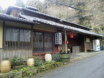  |
| Left: Tea house of Kyomi-toge Pass (on Nagasaka-goe Path), Right: View from near Board Number 69 |
|
Go up the steep slope from Board No. 68 on Kyomi-toge Pass. The path among the forested site becomes gentle. From Board No. 69, you can enjoy the view of Kyoto. You will soon see a small log house at Board No. 70 and here the path merges with the other path which comes from Himuro-wakare. If you take the other course from Himuro-wakare, turn to the right at Board No. 67-1 to the direction of Sugisaka. You will see the Jizo-hokora (small jinjya shrine with jizo stone statue) on the rock. This area is Yaritogiiwa-cho Town. The names of Yagitoriiwa and Senzoku remind us of the age of provincial wars. Pass through Maesaka Village and turn to the left at Board No. 67-2. Take the left forest path from Board No. 67-3 and go to the end of the path where Board No. 70 is placed by the log cabin on the col. Go a little further to Board No. 71 and take the left mountain path. Follow the sign boards and go down the steep slope to the end of the down slope to Kaminomizu-toge Pass (Board No. 75 and No. 76). The path which goes down the pass to the northwest is Kyoto Trail Course (Tokai Nature Trail). The path which goes down to the east to Senzoku/Takagamine is the detour path during autumn pine mushroom season. At Board No. 77 goes up to the south. No. 79, where the Course Guide Board is also placed, the path merges with a paved forest road. This road comes up from Route 162 through Bodai-no-taki Falls. If you continue to go up on the forest road, you can reach Sawano-ike Pond. |
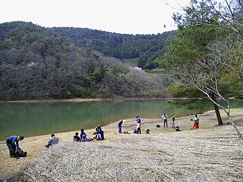  |
| Left: Sawano-ike Pond, Right: The path along Kiyotaki-gawa River |
|
Sawano-ike Pond (height: 340 m, Board No. 80) was an irrigation reservoir for Sagano district in Ukyo Ward, Kyoto City and is a spacious pond in a quiet mountain with the light surface. Go up further from the end of the forest road. You will reach Hotogaya-toge Pass (Board No. 82). Turn to the right at Board No. 82 and turn to the left at Board No. 84. Soon the path becomes deeply hollowed steep downward path. Go down carefully. You will reach the junction of paved Hukugatani Forest Road (Board No. 85). Go down the paved forest road to the northwest. You will be led to Board No. 85 placed on the fork place with paved Hukugatani-rindo (forest road) after the forest becomes spacious and light. Go down the paved forest road heading to the northwest. The Kitayama Course of Kyoto Trail runs through well maintained forests of straight beautiful cedar trees in many parts. Logs of these cedars are polished for Kitayama migaki-maruta. Go down Hukugatani-rindo (forest road) to Hakuun-kyo Bridge over Kiyotaki-gawa River on Route 162 in Makino-o region. Board Number 87 is placed beside the bridge. If you turn to the right at the national road, cross the bridge and go about another 200 meters, you will reach Toganoo Kozanj-ji Temple. The Trail Course goes to the left at Board No. 87 on the national road. Go for about another 200 meters to Board No. 88 and turn to the right to Takao Jingo-ji Temple area. Please look out for cars on the national road as there are no sidewalks along the road. Around there, Kiyotaki-gawa River becomes deep valley. You will see Shigetsu-kyo Bridge with red bridge rails. If you go up the stone stairs, you will be led to Saimyo-ji Temple. This temple is a branch temple of Jingo-ji Temple founded in the Tencho era. You can enjoy beautiful azalea (kobano-mitsuba-tsutsuji) in full glory all around the hills behind the temple in spring. There is a long approach road of stone stairs to Takao Jingo-ji Temple after crossing Takao-bashi Bridge. This temple is Bekkaku-honzan (special head temple) of Koyasan Shingon sect. It is a mountain temple founded at around 200 meters high. Go further along the river and you will find toilet facilities and then water intake dam of Kiyotaki Power Plant of Kansai Electric Power. The forest road ends at Board No. 91. Over Senbotsu-bashi Bridge, there is an open space where cherry blossoms bloom beautifully in spring. Go further along the river. Watch your steps as the path is very slippery in wet weather, and also you have to look out for falling rocks. This area is called “Kin-un-kei” |
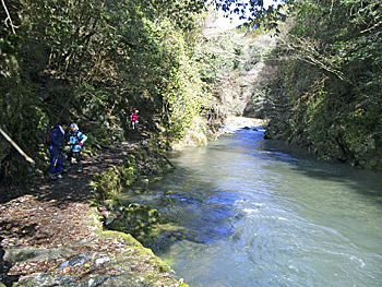 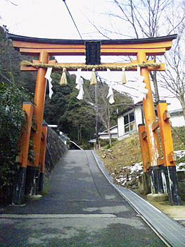 |
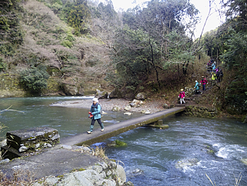
| Left: Kin-un-kei, Right: Starting point of the main approach path to Mt. Atago-yama (Kiyotaki) |
|
After crossing Dosho-gawa (Dojiri-gawa) River which flows from Kubinashi-jizo and Kuyano-taki, the path becomes upward. Turn to the left at Board No. 92 on the hairpin like curve. You will meet the path to Tsukinowa-dera Temple. The trail course goes down to the left on the paved forest road. Soon you will find Board No. 94 beside Kinrei-kyo Bridge at the starting point of the main approach path to Mt. Atago-yama. It takes about 2 hours and 30 minutes to go up to Mt. Atago-yama on the main approach path. Also you can go up to the top of the mountain from Board No. 93 through Tsukinowa-dera Temple. Kyoto Trail Course becomes “Nishiyama Course” after Board No. 94. Go to Kiyotaki Bus Stop passing by Board No. 1 of Nishiyama Course which is placed beside Toen-kyo Bridge. 《Approximate time required》 Fork point of Kyomi-toge Pass (No.68) (15min.← →20min.) Log cabin on the col (No.70) Himuro-wakare (No.67-1) (15min.← →10min.) Restaurant (No.67-3) (10min.← →15min.) Log cabin on the col (No.70) Log cabin on the col (No.70) (40min.← →35min.) Kaminomizu-toge Pass (No.75) (10min.← →10min.) Forest road (No.79) (15min.← →15min.) Sawano-ike Pond (No.80) (15min.← →20min.) Hotoguri-toge Pass (No.82) (15min.← →15min.) Fork point of the ridge way (No.84) (25min.← →20min.) Junction with Fukugatani-rindo forest road (No.85) (40min.← →30min.) Hakuun-kyo Bridge (No.87) (5min.← →5min.) Makino-o Bus Stop (No.88) (30min.← →25min.) Senbotsu-bashi Bridge (No.91) (15min.← →15min.) Fork point of Nashinoki-rindo forest path (No.93) (10min.← →10min.) Kiyotaki Kinrei-kyo Bridge (No.94) Senzoku (→50min.) Kaminomizu-toge Pass (No.75) Fork point of Kyomi-toge Pass (No.68) (4hours and 5min.← →3hours and 45min.) Kiyotaki Kinrei-kyo Bridge (No.94) (when you go through Yaritogiiwa-cho Town) |
| → Western Kitayama Course (Trail Board Number 47 to 68 of Kitayama Course) |
| → Nishiyama Course (Trail Board Number 1 to 24 of Nishiyama Course) |
| → High points |
| → Back to the Top of this Page |
| © Kyoto Trail Guide Association |