
|
| ■Kitayama East Course (from Hiei Station of Cable Car to Ninose, 17.9 km) |
| From Hiei Station of Cable Car to Ohara/Todera (from Board Number 1 to Number 23) |
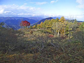  |
| Left: View of Mt. Yokotaka-yama, Right: Stone stairs leading down to Jyodo-in Temple |
|
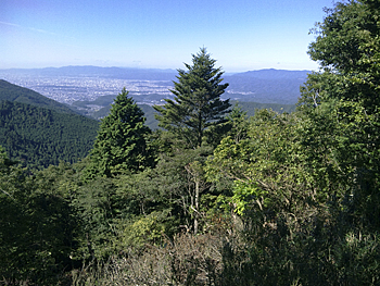
“Kitayama East Course” of Kyoto Trail Course starts from Hiei Station of Cable Car. Go up along the motor vehicle way from Board No. 1 which is placed in front of the station to the closed Mt. Hiei artificial ski slopes (Board No. 2). The ski slope is now covered in fields of Japanese silver grasses and ski lodges lie in ruin and are pensive. Go up the mountain path along the left side of the ski slope to Board No.3 and then go down the wider slow slope. Walk for a while and you will find a very good place for rest (Board No.4) where you can enjoy a view of the mountain ranges of Kitayama. If you take the path which goes up to the mountain side, you will reach the top of Mt. Daihiei (848.1 m) in about 20 minutes. |
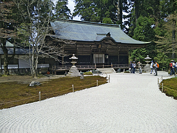 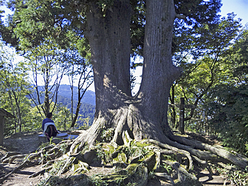 |
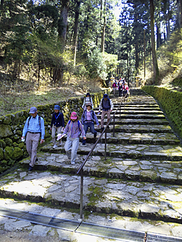
| Left: Jyodo-in Temple, Right: Gyokutai-sugi (cedar tree) |
|
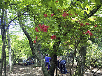
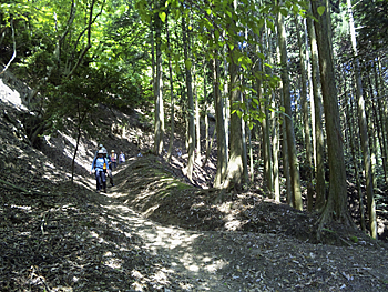
Pass by the stone monument of chingo kokka (national pacification) (Board No. 5) to Board No. 6, which is placed on the near side of the bridge spanning over the driveway. If you go straight for about 15 minutes, you can visit Enryaku-ji Temple Konponchu-do Hall (entrance fee for pilgrimage: JPY 700/ person). If you take the Trail Course, you will be led to the front of Jyodo-in Temple after crossing over the bridge and going down wide stone stairs. There is the Mausoleum of Dengyo Daishi Saicho and these areas are considered as the most sacred places for religious services. Turn to the left at the front of Jyodo-in Temple and head to Shaka-do Temple on the new well-kept approach. Go down the moss-covered stairs to the right at Board No. 8. The quiet path among cedar trees merges with the wide temple approach at Board No. 9-1. Soon you will arrive at Shaka-do Temple (Board No. 9-2). This temple is also called Tenhorindo Hall. This temple has been relocated from Kon-do Hall of Onjo-ji Temple (Mii-dera Temple). This is the oldest building around Mt. Hiei and was built in the irimoya style (half-hipped roof style) with copper tiles. Go up the approach on the right side of Shaka-do Temple from Board No. 9-2 to Kojirin-dojyo. Toilet facilities on the near side of Shaka-do Temple are the last ones in this trail course. Go further for a while, pass through the tunnel under the driveway and get into the Kaihogyo-do (Mine-michi) from Board No. 10-2. At Board No. 11-1, the trail course crosses with the forest path which goes down to Kurotani Seiryu-ji Temple. Kurotani Seiryu-ji Temple was a place where Enkan Shonin trained. His activities were discribed in Taiheiki. Also, the temple grounds have been designated as a "Mt. Hiei Bird Breeding Area." Go up the Mine-michi which runs along the driveway and you will find the Gyokutai-sugi (cedar tree) on the small peak. It is a nice place for rest. There is a stone stool in the shape of a lotus. From here, practitioners worship the Imperial Palace. |
  |
| Left: View of Kyoto urban district from Mine-michi, Right: Top of Mt. Yokotaka-yama |
|
Go down to the north to the pass called “Mine-tsuji” (Board No. 12). If you take the path (Mine-michi) which goes to the right, you will be led to Yokawa Chu-do Hall after passing through the tunnel under the driveway. Go up the steep ridge slope and you will reach the top of Mt. Yokotaka-yama (767m). Go down a slow slope to the next saddle shape place and then go up a steep slope again to the top of Mt. Mizui-yama (793.9 m). This is the highest point in the Kyoto Trail. The downward path with some steep slopes merges with Tokai Nature Trail at Board No. 17. |
 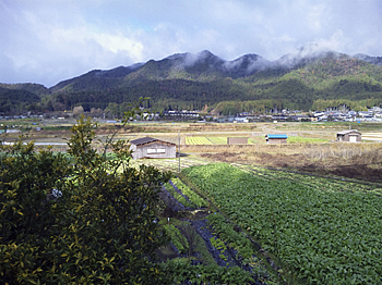 |
| Left: Path to Ogi-toge pass, Right: View of Ohara (center is Mt.Konpira-san) |
|
Ogi-toge pass (573 m) is on an old path which connected Ogi and Ohara. Some say that Ushiwakamaru used this path when he headed towards Oshu accompanied by Kichiji Kaneuri. Go down for about 10 minutes from Board No. 18 placed on the pass. The path is divided into two at Board No. 19; the trail course and the pass route. The trail course is also called the Boy Scout route. It is a steep slope path running among forested site. Go down carefully. The path merges with a forest road at Board No. 21. Open the fence gate and get into the village. Please close the gate properly. Going down to the end of the slope, you will find Todera Bus Stop on your left. 《Approximate time required》 Hiei Station of Cable Car (Kitayama Course No.1) (40min.← →35min.) Pedestrian bridge of Driveway (No.6) (25min.← →20min.) Shaka-do Hall (No.9-2) (40min.← →40min.) Gyokutai-sugi (10min.← →5min) Mine-tsuji (No.12) (10min.← →15min.) Mt. Yokotaka-yama (No.13) (25min.← →25min.) Mt. Mizui-yama (No.16-1) (60min.← →40min.) Ogi-toge pass (No.18) (20min.← →15min.) Branching point to the Boy Scout route (No.19) (60min.← →45min.) Todera Bus Stop Hiei Station of Cable Car (Kitayama Course No.1) (4hours and 50min.← →4 hours) Todera Bus Stop |
| → Higashiyama Course (Trail Board Number from52-2 to 74) |
| → Eastern Kitayama Course (Trail Board Number 24 to 46 of Kitayama Course) |
| High points |
| → Back to the Top of this Page |
| © Kyoto Trail Guide Association |