
|
| ■Nishiyama Course (from Kiyotaki to Kokedera-dani, 10.7 km) |
| From Arashiyama to Kokedera-dani (from Board Number. 24 to Number. 51) |
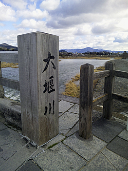  |
| Left: Downstream of Oi-gawa River and Mt. Hiei-zan, Right: Path to Mt. Matsuo |
|
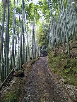
Go to the southwest on the paved road from Nishiyama Course Board No. 24 which is placed in front of Arashiyama Station of Hankyu line. Go to the T-junction (Board No. 25) and turn to the left. If you turn to the right, you will see the big stone monument of Horin-ji Temple on your left side and the approach to the temple. As the road is very narrow and there is a lot of traffic, please watch out for cars. Horin-ji Temple is well-known for Jusan Mairi (a temple visit made by 13-year-old children to give thanks for their coming of age) and also for Harikuyo (memorial service for old needles). Starting point for Mt. Matsuo-yama (Board No. 26) is near the garage fence. Following the direction, get into the small path. The trail path is a slow upward slope among bamboo trees. At Board No. 28, turn into the mountain behind of Horin-ji Temple. Turn to the left at the junction of Board No. 29. If you go straight, you will reach the Arashiyama Monkey Park (Mt. Iwatayama). The trail path becomes ridge way. Going up the steep slope with exposed rocks to the top, you will reach the crossroad where Board No. 32 is placed. The trail course returns to this place after a loop trip to the triangular point of Mt. Matsuo-yama. |
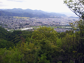  |
| Left: View of Mt. Sawa-yama direction, Right: Top of Mt. Matsuo-yama |
|
Get into the right flat path in the cedar forest. From the right ridge, you can enjoy the view of Togetsu-kyo Bridge below your eyes and also a magnificent view of the mountains from Sagano to Rakuhoku. If you go straight from Board No. 33, you will be led to Mt. Karasugatake district. There is Arashiyama-jyo castle ruins along the way. Going up to the left among trees, you will reach the top of Mt. Matsuo-yama (275.6 m), Board No. 34. On the way back from the top of the mountain, turn to the left at Board No. 37, and you will return to the crossroad of Board No. 32. Go down the steep slope to the east. From Board No. 38, go down to the right. Watch out your steps as the path is slippery especially in the wet weather. Around Board No. 40 is the mountain behind Matsuo-taisha Shrine. At the peak of Board No. 43, where the mountain paths in the thicket cross crosswise, an orienting marker for minor controlling point of Geographical Survey Institute has been placed. |
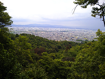  |
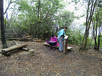
| Left: View of the south part of Kyoto City (view from the ridge of Kokedera-dani), Right: Going down to Saihoji-gawa River from Board No. 51 |
|
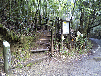
The place of Board No.44 is an irregular cross road. The path going to the left is a well-trodden path, but from the upside of Suzumushi-dera the path becomes sharply steep. Go down to the small temple hall in Matsumurojike-cho. Go straight on the Trail Course. After you see bamboo tree field on the left side, the path becomes sharply steep. Between Board No. 45 and Board No. 49, the path is narrow and it is easy to take a wrong path, and therefore, many Boards are placed on the path. Turn to the right at Board No. 50, and you will reach Matsuo-rindo (Board No. 51). This is the final place of the current Kyoto Trail Course. Followings are the further note for how to get to Kokedera Bus Stop (Kyoto Bus) and Matsuo Station and Kamikatsura Station of Hankyu line. Go down the paved forest road along Bamboo tree field. Saiho-ji (Koke-dera) Temple is beyond trees on the left, over the bridge. After passing by the entrance gate of the temple, you will find Ike no Taiga Art Museum on your left. Ike no Taiga was an artist in Edo era who was born in Kyoto. He was considered as one of the master of literati painting as well as Yosa no Buson. Kokedera and Suzumushidera Bus Stop is located diagonally across from the Museum. Suzumushi-dera Temple is on the left beyond the open space of the bus stop. On the way to Matsuotaisha Station of Hankyu line, Tsukiyomi-jinjya Shrine is located. This was a venerable shrine mentioned in the Engishiki. It was considered that the shrine was originally revered as the deity controlling safety of the ships in Ikinoshima Island. The enshrined deity is Tsukuyomi no mikoto. Matsuno-o-taisha Shrine was the ujigami (guardian god) of powerful toraijin of Hata-clan (people from overseas, especially from China and Korea, who settled in early Japan and introduced Continental culture to the Japanese) around Uzumasa, Saga and former Otagi County. It is spectacular to see piled many Sakadarus (sake barrel) which were dedicated by breweries all over Japan. Also, this shrine is famous for beautiful Japanese roses. To Kamikatsura Station of Hankyu line, go up the stairs beside the open space of Kokedera Bus Stop of Kyoto Bus and follow the direction sign of Tokai Shizen Hodo (Tokai Nature Trail). Jizo-in Temple, also known as Takeno-tera, is located ahead on the right. Turn to the left at the next crossroad. Go straight on Tokai Nature Trail. The road heading to the right is a historical old path of Karatogoe (Akechigoe). Cross the intersection of Mozume kaido Road and go straight further. The station is close after seeing the crossing. 《Approximate time required》 Arashiyama Station of Hankyu line (No.24) (5min.← →5min.) Starting point for Mt. Matsuo-yama (No.26) (20min.← →25min.) Crossroad (No.32) (10min.←Mt. Matsuo-yama (No.34) →15min.) Crossroad (No.32) (20min.← →25min.) No.43 (30min.← →20min.) Matsuo-rindo forest road (No.51) (10min.← →10min.) Kokedera Bus Stop Kokedera and Suzumushidera Bus Stop〈20min.← →20min.〉Matsuotaisha Station Kokedera and Suzumushidera Bus Stop〈20min.← →15min.〉Kamikatsura Station Arashiyama Station of Hankyu line (No.24) (1hour and 35min.← →1hour and 40min.) Kokedera Bus Stop |
| → Nishiyama Course (Trail Board Number 1 to 24 of Nishiyama Course) |
| → keihoku Course (Trail Board Number 1 to 34 of Keihoku Course) |
| → High points |
| → Back to the Top of this Page |
| © Kyoto Trail Guide Association |