
|
| ■Keihoku Course (Hosono (starting place) ―Hosono (finishing place), 35.4km, Trail Board Number from K1 to K19, 5.5km) |
| From Sanryo-bashi Bridge to Miya (Trail Board Number from K1 to K19 / From Sanryo-bashi Bridge to Shimokumata (Trail Board Number from 34 to Number 68) |
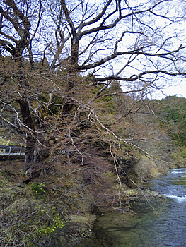 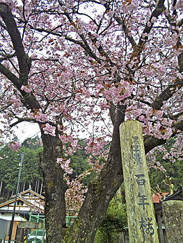 |
| Left: Big zelkova tree at the foot of Nakano-bashi Bridge Right: 100-year-old cherry tree in Miya |
|
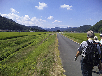
After crossing Sanryo-bashi Bridge, go on the left bank to the upstream of Kamikatsura-gawa River. Near Eguchi-bashi Bridge, the path becomes close to the river. Just before the bridge, go down the steps to the riverbed and keep going to Nakano-bashi Bridge on the left bank. Some places are rough for construction work. There is a big zelkova tree at the foot of Nakano-bashi Bridge on the right bank. We can enjoy its attractiveness through the year. Go on Route 477 without pavement and go up to Kakeo-toge Pass from Board Number K9. We can smoothly go up a small pass with elevation of about 100 meters to Kuroda Power Plant thanks to the widely winded river.Go to Shimokuroda on the National Road. After crossing Tsuno-bashi Bridge, you will reach Kuroda Tunnel. The Trail Course goes down to Miya through Miyasaka-toge Pass from just before the tunnel. Go up a little to the north from the top of the pass, and you will find Kuroda-hachijuhachi-inari-jinjya Shrine. Go down the approach of the shrine. Beyond the old Kuroda Elementary School, there is Kasuga-jinjya Shrine which is a branch shrine of Kasuga-taisha Shrine in Nara. At the entrance, there is a 100-yrear-old-cherry tree which is famous for rare single and double flowered yamazakura species kept by Sakura gardeners Toemon Sato and his son. Local people also love it with great care. The season of the cherry blossoms in Jyosho-koji Temple is earlier than that in Kasuga-jinjya Shrine, and therefore it is difficult to enjoy both cherry blossoms at the same time. |
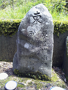 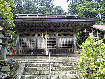 |
| Left: Stone marker at Ido-toge Pass Rght: Hachiman-gusha Shrine |
|
To go to Ido-toge Pass from Sanryo-bashi Bridge, take the path to the west from the below part of the parking lot of Jyosho-koji Temple (Board Number 35). The driving way goes on devious route to the pass, but the old path goes in the cedar forest by the most direct way. There is a stone marker and a stone Buddhist image at the col. Also, there is a path on the ridge running in a north-south direction. This is a very important place as six old and new routes connect here. Select route according to your time schedule and condition.Going down along wide and bright Tsutsue-gawa River, you will reach Route 162 after passing through Tsutsue village full of flowers. There is Otabi-sho of Kumano-jinjya Shrine just before the junction. Cross Tsutsue-bashi Bridge over Yuge-gawa River and go to Keihoku-daisan Elementary School. Go around the north side of the school building from the main gate and you will find Hachimangu-sha Shrine on the right side of the junction of three streets. The shrine yard is always calm and quiet. |
  |
| Left: the path along Kaminaka-suiro (water way) Right: Hosen-ji Temple in Shimokumata |
|
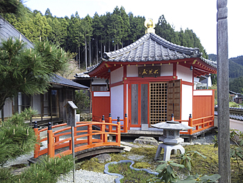
There is a big cedar tree with a trunk over 6 meters around in the school yard. It is suggested that this place used to be an approach to the shrine. Kaminaka is a rural area with fields of rice and other crops. Old Kaminaka Castle is maintained as a park and there is an azumaya (small arbor) on the course along Kaminaka water way. This is a precious castle built in the late Heian era on the flatland. Soon after hitting Yuge-gawa River, cross Sawa-bashi Bridge to the left bank and go along the river. Original course goes to the west from Yatanikami-bashi Bridge to Kumata through Yatanigoe. But as of 2011, it is not available to walk the path because of construction work. In spring of 2012, the consolidation memorial park will open. For now, go downward along the river to Eirinji-bashi Bridge and cross to the right bank. Turn to the right at Deguchi-bashi Bridge to Kumata through Nakiwakare-toge Pass. The path merges with the original path at Kumata-bashi Bridge over Kumata-gawa River. Turn to the left toward the lower reaches along the right bank. Turn to the left to Utaki area at Hoitani-bashi Bridge in Shimokumata. If you turn to the left just before the bridge at Trail Board Number 66, you can visit Hosen-ji Temple which is famous for beautiful iris flower. This is a Buddhist temple of the Omuro school of the Shingon sect and enshrines Jyuichimen Kannon Bosatsu (11-faced Kannon Bosatsu). |
| 《Approximate time required》 Sanryo-bashi Bridge (No.K1) (35min.) Nakano-bashi Bridge (No.K8) (45min.) Kakeo-toge Pass (No.K12)( 55min.) Tsuno-hashi Bridge (No.K14) (10min.) Miya (No.K19) Sanryo-bashi Bridge (No.34) (50min.) Ido-toge Pass (No.37) (50min.) Tsutsue (50min.) Yatanikami-bashi Bridge (No.53) (35min.) Deguchi-bashi Bridge (No.Y3) (25min.) Kumata-bashi Bridge (No.64・65) (20min.) Board Number No.68(junction of the three streets) |
| → Keihoku Course (Trail Board Number from 1 to 34) |
| →Keihoku Course (Trail Board Number from 68 to 1, 71 to Shiroyama, and to Shuzan) |
| → High points |
| → Back to the Top of this Page |
| © Kyoto Trail Guide Association |